

Fred Meijer White Pine Trail is the longest linear state park in Michigan. It runs from Comstock near Grand Rapids to Cadillac at the total length of 93 miles. The entire trail runs parallel to US-131, and therefore is fairly easy to access. Not all of it is completely finished. There are long sections (Sand Lake to Big Rapids) that are just two-track in the woods. Sometimes, a little rough. However, the section from LeRoy to Cadillac, which this post covers, is fully paved.

White Pine Trail – Cadillac – LeRoy Section
The distance from Cadillac to LeRoy is only about 17 miles. The trail is pretty flat. The surface is quite smooth, and the only cracked pavement I encountered was a short section out of Cadillac.
Cadillac Area
The trail officially begins in Waterfront Park in Cadillac (according to Google Maps and Michigan Trail Magazine). However, I did not see any signs in the park indicating that. And if you reference Google Maps, it shows that the trail goes through the park by the lake. However, I saw a sign on the south side of the park, saying no bicycles allowed. But south of the park, when the trail is following the sidewalk, riding is O.K.
On the other hand, on the Cadillac metal map that I found, the trail begins at the intersection of S. Lake St. and South St. (where the White Pine Trail sign is). But there is no parking lot there.
So, again, it is the same problem, as with many Michigan trails, where the beginnings are not well defined, and the trail is not well marked.
As I have mentioned above, the first sign indicating that I am on the White Pine Trail was on the south side of the intersection of S. Lake St and South St. (GPS coordinates: 44.2450266, -85.3992669)
From there the trail quickly enters the woods, and you immediately feel being outside of the city, even though, you still, for a while ride through residential areas of Cadillac. However, you view is obstructed by the vegetation.
Just about mile and half from the start, you come up to the first trailhead, or staging area, as they call it. It is the Cadillac Staging Area.
Between Cadillac and Le Roy
The surroundings will change to more open fields and some forest ponds, bogs, etc. Nothing exciting, but the common Michigan country landscape.
After riding 12 miles you will arrive in Tustin, a sleepy town with a population of a little over 200 residents.
Keep riding south on the trail and soon you are in woods and open fields again.
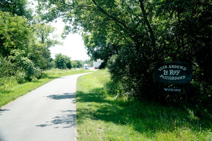
After riding about 5 more miles you get to the town of LeRoy. Even smaller and sleepier than Tustin, with a similar population.
The trail is smooth and fairly quiet, with low usage. and the only place where you will encounter more users is in the Cadillac immediate area.
Trail Usage
As I mentioned before, the trail see pretty light usage, which means that you will occasionally pass somebody. However, there will be sections, where you will be alone for few miles.
I ran into cyclists and walkers mostly. Only in Cadillac, I also encountered few runners.

Scenery
As far as scenery, the trail goes through a typical Michigan inland landscape – woods, open fields, some ponds and bogs. As such, it is monotonous and relatively boring. The pond that you see in a picture below was probably the most scenic highlight of the entire trail.
Of course, in Cadillac, you have some nice views of the Cadillac Lake, but as you start riding, the lake is almost immediately out of sight.

Trailheads
The trailheads following south from Cadillac are:
- Waterfront Park – there is plenty of parking at the Waterfront Park or across the street. There are also a public restroom there and water. (GPS coordinates: 44.2477981, -85.4004606)
- Cadillac Staging Area – Parking lot with several parking spots and a port-a-potty. (44.2227623, -85.426570)
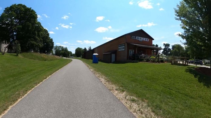
- Tustin/Pine River Museum Trailhead – Another parking lot with several parking spots and a port-a-potty. (44.1013519, -85.4567553)
- LeRoy Trailhead – There is a parking lot, port-a-potty and a pavilion with picnic tables. (44.0379348, -85.4520206)

Trail Amenities
There are not even simplest amenities on the trail. No benches, picnic tables, water pumps.

Off Trail Amenities
Cadillac – There is a supermarket practically by the trail. There are few cafes, breweries, fast foods relatively close to the trail. Then there is nothing till Tustin.
Tustin – There are two restaurants and a store.
LeRoy – There are two restaurants immediately north of LeRoy, almost along the trail. There is farmers market on the south side of town.

Final Thoughts
The White Pine Trail section described above is great for getting some miles on the bike, going for a relax longer ride. There are not many roads to cross, there is not much traffic on the trail.
The trail is NOT good, if you are looking for some scenery.
It is a long trail and is connected to more trails in Reed City (Pere Marquette Trail) going to Evart and further to Midland. There are even more connected trails at the south end of White Pine, in Grand Rapids. For that reason, it is a great trail for a multi-day touring in Michigan.
My Ratings
Scenery (0-boring, 10-breathtaking): 3.0
Easy-to-Follow (0-no maps, often broken into section without clear directions, 10-well marked with maps showing current location): 8.0 (. It is a linear trail and its easy to follow, once you are on it.)(I gave it only “eight” because of poor markings in Cadillac… Occasionally, there are maps and mile markers along the trail.)
Food Access (0-no food facilities at all, 10-food available every few miles): 2.0 (very few choices in towns only.)
Restrooms (0-none, 10-moderen restrooms every few miles): 3.0 (restrooms at trailheads only)
Surface Quality: 9.0 (Paved and really smooth trail. Only cracked pavement area immediately out of Cadillac.)
Accessibility: 5.0 (few trailheads with parking lots)
Usage (0-not used at all, 10-extremely popular): 4.0 (relatively low usage)
Hills (0-completely flat, 10-Extremely hilly): 0.0 (quite flat)
Sun/Shade (0-no shade at all, 10-competely shaded): 3.0 (very little shade)

Resources
- Michigan Trails Magazine – White Pine Trail (entire trail)
- Michigan Trails Magazine – White Pine Trail (Reed City to Cadillac)
- Friends of Fred Meijer White Pine Trail
* * *
If you are interested in White Pine Trail, you might want to check my posts about other trails in the area:
- Great Riding on the Leelanau Trail
- Betsie Valley Trail – One of the Most Scenic Trails in Michigan
- Biking the Popular Sleeping Bear Heritage Trail

I would like to offer an update and comment on some of your remarks and ratings of the Cadillac to Leroy section of the WPT. Yes, you make a very good point about signage at the north terminus of the WPT in Cadillac, HOWEVER, this summer that deficiency was corrected with the construction of a very nice Trailhead. Second, seven more miles of the WPT were paved this summer – from Sand Lake to Howard City, with the remaining 22 miles scheduled to be paved in summer 2023.
You state the number of riders was light. Yes, that would be expected, as your ride occurred in April on a Tuesday, so not everyone has their bike out yet and many people work during the week.
You say the trail is NOT good if you are looking for scenery. While you are certainly entitled to your opinion, many of us actually enjoy the open fields, wildlife and the serenity those scenes provide.
You rate Accessibility as a 5 and state “few trailheads with parking lots.” I’m confused by that assessment, as this 17-mile stretch had three towns and every one has a parking lot.
Finally, your assessment of this 17 mile stretch of the WPT only represents 18% of the 92 miles and I would encourage you to experience some of the other 75 miles of this national Top 100 Rails-to-Trails trail, as determined by the National Rails to Trails Conservancy, with a variety of scenery and 15 varying size towns.